I hiked up the highest peak in Utah (13,528 feet) on August 1, 2009. I started at the Henry's Fork trailhead (9,430 feet) at 6:40 am. From Henry's Fork, it is approximately 16 miles one way. I don't know exactly how far it is because of the conflicting information on the web and I didn't take a GPS with me. (If anyone has taken a measurement of the distance of this hike, let me know). Most people take 2 to 3 days to make the round trip, with a few people hoofing it in one day.
Here's the sign at the trail head, welcoming you to the high Uintas. The weather was beautiful.
The first few miles of the hike look like this picture. Fairly dense tree cover, a few rocks in the well-marked trail, and sturdy bridges over a few streams along the way.
About 45 minutes into my hike, I came to this sign. It points to Aligator Lake, which is about 2 miles from the trail head. I noticed a small camp off the right side of the trail.
At 8:15 am, about an hour and a half into the hike, I decided to stash some water off the side of the trail. Most people bring a pump to filter stream water for drinking along the way. I don't have one of those and I didn't want to spend the money to get one, so I had to pack in all my own water. I decided I would stash some along the trail on the way in so I wouldn't have to carry it the whole way.
More pictures from the first couple of hours of the hike.
At 8:30 am I hit Elkhorn Crossing. Ford the stream.......?
........ or cross on the foot bridge?
I chose the bridge. About 15 minutes later, I came out into opening. Wow, I still have a long way to go.
From here, I don't think King's Peak is visible, but I know I'm pointed in the right direction. I should mention at this point that I have been walking past a steady stream of Boy Scouts on their way out.
I asked one of the scout groups to point out King's Peak. They said it is the pointy one, the farthest away in the middle of the picture. I took this picture at 8:55 am.
About 15 minutes later, I came upon this "Campfire Closure Order". It basically said that campfires are prohibited within a quarter mile from Dollar Lake and Henry's Fork Lake. Has something to do with dead wood depletion and its effect on the ecosystem.
Just past the campfire closure sign, I ran into this gentleman with his llama. You can see King's Peak off in the back ground. At 9:30 am, I stashed some more water on a big boulder right by the trail.
Just a few more minutes up the trail, I got to this sign, off the right side of the trail. It points out Henry's Fork Basin off to the right and Henry's Fork Trail to Gunsight Pass straight ahead. Again, you can see King's Peak in the back ground.
This is a view of Gunsight Pass (11,888 feet).
At about 10:30 am, I made it over Gunsight Pass and took this picture. South King's Peak is on the far left. King's Peak is somewhere behind those crumbling cliffs. I didn't expect to see this large boulder field and the crumbling cliffs above me. Notice the size of the boulders all around me. Much larger than me. They look very different from the top of the mountain. I've got a little more than 2 hours to go to the peak.
I should mention at this point I started feeling what I thought was dehydration. I was starting to get a head ache. I didn't know I was feeling the altitude. As I got closer to the peak, my head hurt worse, it felt like a migrane. When I got up above probably 12500 feet, I had to stop every few steps to keep my heart from beating out of my chest. Also, from the altitude.
I took this picture close to the peak. It looks like these flat rocks were stacked like this and they could topple over any time.
I turned around and took this picture in the direction from which I came. That boulder field I was standing by a couple of hours ago now looks like sand.
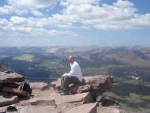
12:45 pm: I made it! The view is amazing. I head is aching. I stayed for 20 minutes and started to make my way back down. I remember being a little worried because I was feeling so sick and I knew I had 6+ hours of hiking to get back to my vehicle. I didn't know I was feeling sick because of the altitude. I happened to have some excedrine in my pack, which I took. By the time I got back down to the tree line, about 10500 feet, I was feeling great.
Here's the boulder I stashed some of my water at. My water is just to the left of this marmot. I didn't think he was going to let me retrieve it.
Once I got over the altitude sickness I was experiencing, I made good time back to the trail head. I hit my truck about 6:45 pm, 12 hours after I started.
This was a great hike, one that I will definitely do again next year.
Lesson learned: Be prepared for the altitude sickness. Let me know if you have any tips to reduce the effects of high altitude.


No comments:
Post a Comment